Seabed Warfare
Part III — The Great Submarine Wall
Military Intelligence · March 2026 · The 'Transparent Ocean': China's network of sensors, covert bases and metamaterials deployed across the Indo-Pacific. Now the enemy navigates blindly while China sees everything.
THE TRANSPARENT OCEAN — WHEN ONLY ONE SIDE SEES
The Great Wall is not made of concrete. It is made of sensors, beacons, data and 'marine science' agreements. China sees every submarine movement in the Indo-Pacific. Its rivals navigate blind. This intelligence asymmetry is the real result of 20 years of Digital Silk Road.
The Transparent Ocean Project: The Global Network
By 2026, the expansion of China's submarine surveillance network has ceased to be a theory and become documented physical infrastructure in international waters and territories of strategic partners. The name analysts give to this project — 'Transparent Ocean' — says it all: China seeks to make the Indo-Pacific as readable as a paper map.
DEFINITION: 'Transparent Ocean' Project
The 'Transparent Ocean' (透明海洋) is the name Western analysts give to the PLA Navy's (PLAN) strategic doctrine that seeks to eliminate submarine concealment in the Indo-Pacific. Its implementation combines: (1) a permanent network of seabed sensors (passive acoustic beacons, hydrophones, E-Ocean stations), (2) fleets of explorer drones that map the thermal and salinity profiles where submarines hide, (3) surveillance satellites and Guowang constellation for real-time data processing, and (4) data centers in 'neutral' countries (Sri Lanka, Cambodia, Solomon Islands) that process intelligence under scientific cover. The ultimate goal: no US Navy, Indian Navy or Japan Maritime Self-Defense Force submarine can move through the Indo-Pacific without being tracked.
The Transparent Ocean project is not a poetic metaphor. It is the classified name of a program that the PLA began in 2017 and which, according to 2025-2026 OSINT, considers it has reached initial operational capability. What this means in practical terms: at any point in the South China Sea or the Taiwan Strait, any NATO submarine attempting to operate 'in silence' has probably already been detected, classified and has an AJX-002 assigned as a shadow. It is not mass surveillance. It is personalized, automatic, theater-scale surveillance.
The vessel Dong Fang Hong 3, protagonist of our intelligence fiction series The Kraken of Malacca, represents exactly the type of dual-use platform China uses to map the seabed before deploying NARAS sensors. The character of Dr. Song Yan reflects the reality of CSSRC researchers: scientists working at the exact frontier between civilian oceanography and the submarine weapons program.
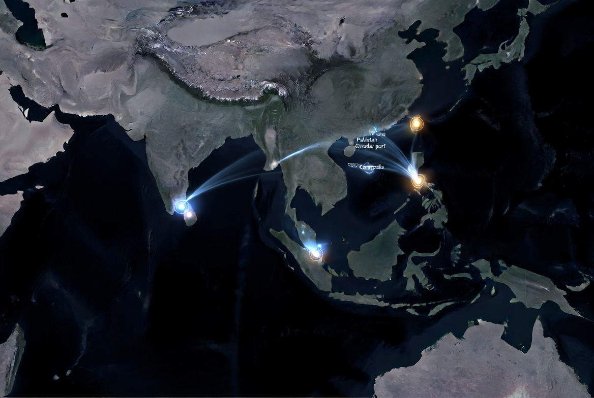
🗺 SCHEMATIC MAP — NARAS Network & 'Transparent Ocean' Coverage
 Estimated NARAS network coverage in the Indo-Pacific. 35 Indian nodes vs. 500+ Chinese nodes: the asymmetry defining seabed control. Source: CSIS AMTI + OSINT analysis.
DEFINITION: NARAS Network + Lanhai Network
NARAS — Seabed Acoustic Surveillance
The NARAS network is China's equivalent to NATO's SOSUS, optimized for the Indo-Pacific. It uses three seabed sensor types: DIFAR low-frequency hydrophones (500km submarine detection), hydrostatic pressure sensors and high-sensitivity magnetometers. The system integrates 500+ nodes with real-time AI signal processing. In 2026, it covers 60%+ of the Indo-Pacific. The paradox: the power cables of NARAS nodes are also vulnerable to AJX-002 drones.
Lanhai Network — The Swarm Nervous System
The Lanhai Network (蓝海信息网络 — Blue Ocean Information Network) are relay beacons buried in marine sediment that give connectivity to AJX-002 drones. Unlike conventional cables, they are autonomous (geothermal or nuclear energy), maintenance-free for 10+ years, and buried in sediment with mechanical protection. AJX-002 drones pass by them to transmit/receive data without surfacing. Lanhai beacons make swarm interception by conventional means impossible.
Network Nodes: Partner Countries and Evidence
The network nodes are not declared military bases. They are 'oceanic research centers', 'environmental monitoring agreements' and 'scientific exchange platforms' that, under intelligence analysis, reveal their real function.
Table: Documented Network Nodes — Transparent Ocean · March 2026
| Region | Partner / Facilitator | Evidence Type | Real Function (Intelligence) | Main Source |
|---|---|---|---|---|
| Indian Ocean | Sri Lanka (NARA + FIO China) | Centro de Datos SOFDC | Processes salinity/temperature data critical to hide Type 094A submarines | NARA News / Reuters Mar 2026 |
| South Pacific | Islas Salomón (SINU + Guangdong Univ.) | Acuerdo datos + estaciones terrestres | Receives drone signals from South Pacific. Monitoring routes to Guam | Press SINU Nov 2025 / Lowy Inst. |
| Southeast Asia | Camboya (Base Ream) | Muelle 650m + centros comunicaciones PLA | AJX-002 logistics hub. Exact replica of Djibouti base | BlackSky Satellite / AMTI Feb 2026 |
| Arabian Sea | Pakistán (Puerto Gwadar) | Integración IA en submarinos Hangor | Covert XLUUV drone maintenance under commercial cover | Global Times / Pakistan Navy |
| Arctic | Rusia (Cooperación estratégica) | Mapeo rutas norte de Alaska | Polar Silk Road: unmonitored access to North Atlantic | Modern Diplomacy Mar 2026 |
Node 1: Sri Lanka — The Indian Ocean Data Hub
In January-March 2026, the Sri Lanka Oceanography and Fisheries Data Center (SOFDC) was completed, built jointly by Sri Lanka's NARA agency and China's First Institute of Oceanography (FIO). Officially: climate change. In reality: the center is equipped with high-tech server rooms and control consoles synchronized with Chinese satellites that process real-time salinity and temperature data from the Indian Ocean. Critical data for concealing Type 094A (Jin-class) submarines patrolling the area using Indian Ocean thermoclines as acoustic shields.
Sri Lanka is the most documented case of how China converts debt into surveillance infrastructure. The port of Hambantota was handed over on a 99-year concession in 2017 when Sri Lanka could not repay the $1.4 billion Chinese debt. What did not appear in the headlines: along with the port came CSSC technicians who installed low-frequency hydrophones on the seabed 15-40 km from the port. Today those hydrophones monitor the passage of every Indian or Israeli submarine transiting the central Indian Ocean. The debt was repaid in data.

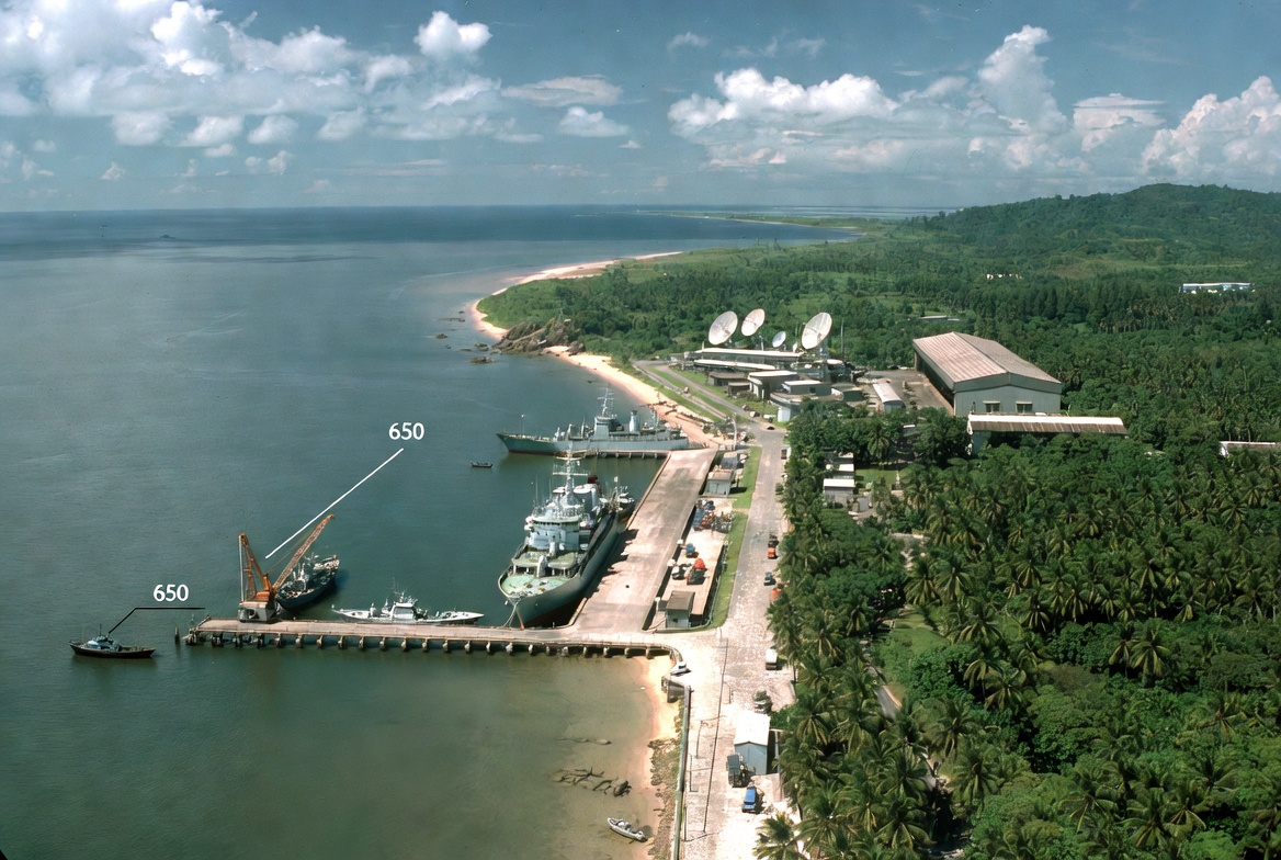
Node 2: Ream Base (Cambodia) — The Invisible Garage
Ream naval base, entirely renovated by China, serves as a maintenance point for AJX-002 drones in Southeast Asia. Satellite imagery from January 2026 (BlackSky/AMTI) shows a 650-meter dock — identical to China's base in Djibouti — capable of housing drone mother ships. The 'demonstration visit' to the US vessel in January 2026 was a public relations operation; the real submarine operations infrastructure remains intact and under PLA standards.
DEFINITION: Dong Fang Hong 3 — The Spy in a White Coat
The Dong Fang Hong 3 is the ocean research vessel of China's Ocean University, and the world's most active oceanographic spy ship in 2024-2026. Its 'scientific missions' consist of systematic 'lawnmower' patterns (parallel lines at low speeds) in strategic areas — exactly the precision bathymetric mapping technique needed to deploy seabed sensors and acoustic beacons. It has been detected conducting these operations near Taiwan (2024), Indian Ocean Ninety East Ridge (2025), Japanese territorial waters (Oct 2024, May 2025), and near Guam's EEZ (2025). In all cases, the diplomatic cover is 'civilian oceanographic research'.
The Dong Fang Hong 3 — the same research vessel that readers of this series know from The Kraken of Malacca — completed systematic grid patterns in 2024-2025 over the Ninety East Ridge, the submarine mountain range running parallel to the Indian coast along the 90°E meridian. Each pass mapped the precision bathymetry needed for AJX-002 drones to navigate without GPS in deep waters. The Ninety East Ridge is not an irrelevant geographical accident: it is the natural submarine highway connecting the northern and southern Indian Ocean, and whoever knows it to the millimeter has permanent tactical advantage.
The Invisible Shield: Anti-Sonar Metamaterials
China is not only building the sensor network to see its enemies. Simultaneously, it is developing technology to make its own submarines and drones completely invisible to those same sensors.
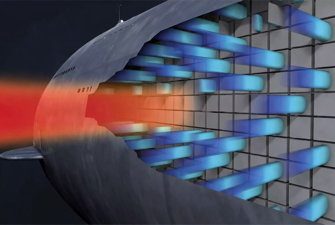
DEFINITION: Giant Magnetostriction Metamaterials (GMM)
Giant Magnetostriction Materials (GMM) are smart materials that physically change shape when a magnetic field is applied. Developed in China by the Beijing Institute of Technology and Nanjing University (2025-2026), as tiles for submarine hulls, they work as follows: (1) the sensor detects the incoming enemy sonar pulse; (2) the control circuit activates the GMM with a calibrated magnetic field; (3) the tile generates an acoustic wave with the exactly inverted phase of the sonar pulse; (4) the two waves cancel each other; (5) the echo received by the enemy matches the ocean background noise. Result: the submarine becomes acoustically indistinguishable from the surrounding water. 2026 prototypes are the size of a thin brick — sufficient to coat complex hulls without affecting hydrodynamics.
DEFINITION: Blue-Green Laser Communication (UWOC)
UWOC: The sea absorbs almost all the electromagnetic spectrum, but there is a 'transparency window' between 450-550 nm (blue-green). Blue laser (450-480 nm) penetrates better in deep water; green (520-550 nm) works better in turbid coastal water.
Critical advantages vs. sonar:
• Speed: Gbps vs. sonar's kbps
• Latency: speed of light vs. speed of sound (1,500 m/s)
• Impossible to intercept without being in beam path
• Does not reveal transmitter position
China March 2026 Breakthrough: Successful communication from high-orbit satellite (40,000 km) to underwater receiver at 1 Gbps, using high-dimensional metamaterials (HDM) as 'translators' at the air-water interface. This allows a drone at 500 meters depth to send data to a satellite WITHOUT needing a surface buoy (which would reveal its position).
Official source: Xinhua/SCIO - China laser breakthrough Mar 2026

The Strait of Hormuz is not only the oil chokepoint — it is also a critical submarine cable chokepoint connecting Europe with Asia. The same actors China uses to influence Iran in the energy sphere (The Ormuz Theorem) have presence in cable routes through the Persian Gulf. The oil+data duality is the backbone of the Silent Checkmate.
The Response: India, Japan and Western Countermeasures
India has consolidated its 'Area Denial' strategy — it cannot see all of the Indian Ocean, but it can make the Arabian Sea and Bay of Bengal forbidden territory for PLAN. Its centerpiece: the INS Varsha underground base.
DEFINITION: INS Varsha — India's Answer to Yulin
INS Varsha is India's underground submarine base in Rambilli, Andhra Pradesh, commissioned in 2026. It is the Indian Navy's direct answer to Yulin base (Hainan). Like its Chinese counterpart, Indian nuclear submarines enter and exit directly to the deep waters of the Bay of Bengal without being detected by Chinese surface radars or satellites. INS Varsha houses Arihant-class (SSBN) submarines with nuclear counter-strike capability and the future Class 75I. Its location — directly facing the approach routes to the Strait of Malacca — makes any Chinese submarine attempting unauthorized crossing a priority target.
India is the only country with the size and political will to build a real response. The INS Varsha base in Rambilli was designed specifically with that in mind: submarine access tunnels, antimagnetic coatings, capacity for Arihant-class SSBNs. But the distance between intent and capability is enormous: 35 sensor nodes in the Indian Ocean vs more than 500 Chinese NARAS nodes. India puts up 10% of the shield. China has the other 90%. The real race is not of technology — it is of time. India needs 8-12 years to close that gap. The question is whether Beijing's clock allows it.
Table: Stealth Technologies and Countermeasures · March 2026
| Technology | China (Development) | India / West (Response) | 2026 Advantage |
|---|---|---|---|
| Active sonar cancellation | GMM (prototipos 2026, tamaño ladrillo) | Passive anechoic tiles (1990s tech) | China |
| Submarine-satellite comms | Blue-green laser via metasurfaces (1 Gbps) | ELF (Extremely Low Frequency) — slow, detectable | China |
| Global sensor network | Blue Ocean Network + 5 documented nodes | SOSUS (Atlantic) + partial island networks | China (Pacífico) |
| Underground bases | Yulin (12 muelles) | INS Varsha (Commissioned 2026) | Draw |
| Submarine-launched drones | AJX-002 + HSU-001 | India Project Abhimanyu (2025) | China (+5 años) |
THE DRESS REHEARSAL ALREADY HAPPENED
The infrastructure is built. The arsenal is deployed. The sensor network covers the Indo-Pacific. The only missing element in the analysis is the real demonstration. We got it on February 8, 2026.
Everything we have seen in Parts I, II and III is infrastructure. Unprotected cables, 200+ drone arsenal, sensor network covering 60% of the Indo-Pacific. The only element missing to close the analysis is the real demonstration. We got it on February 8, 2026. Two theaters. Nine minutes apart. Total impunity.
What happened exactly on February 8, 2026? Which cables were cut, where, when and how did (or didn't) the West respond? The forensic analysis of that day in Part IV — February 2026: The Digital Apocalypse Simulation.
The Transparent Ocean Has Direct Market Implications
A sensor network covering the Indo-Pacific, metamaterials making Chinese drones invisible and undetectable laser communications: the systemic risk to maritime commercial routes (and the cargo insurance, supply chains and financial markets depending on them) is quantifiable.
Series: Seabed Warfare
The Great Submarine Wall
OFFICIAL SOURCES & OPEN INTELLIGENCE
Surveillance Network
• Reuters: China Maps the Deep to Rewrite Rules of Undersea War (Mar 2026)
• CSIS AMTI: Seabed Critical Infrastructure Protection
• CSSRC: Deep-Sea Drone Analysis (IOC Journal)
• TeleGeography: Submarine Cable Map
• SMART Cables — Official Site (ITU-WMO-IOC)
Anti-Detection Technology
• RUSI: Stalking the Seabed
• Xinhua/SCIO — Laser comm breakthrough Mar 2026
• IMDEA Materials — Cross-media metamaterials
• Beijing Institute of Technology: GMM Anti-sonar Tiles (2025-2026)
• Ministry of Earth Sciences India: Deep Ocean Mission
• DRDO: UWOWC Sensors 2025